geography

Amazing maps

The website FarandWide offers blogs maps on a wide variety of topics. Although the website is targeting US citizens who wish to travel, there are interesting topics that may be used by curious person. Particularly interesting are the many sets of maps available: geographical, social, political, historic, current social issues etc.

100 Amazing World Maps

Maps that changed the world

Recently a set of 75 maps were published with data on European countries that may be of interest when travelling. Most maps show when the data were gathered, though with some maps this information is missing. Though this can be a good exercise for students to look at data and information on the web critically.

Maps that show Europe in a new light

Wrong Historical Maps

Two examples of Maps that made us laugh and could be inspiration for students to search for or make their own maps.

See our other blogs on Maps for example: Critical on Maps and Maps of the World

Actionbound – Scavenger Hunt

Actionbound is software that makes it easy to create Scavenger Hunts for your students. The students use an App on their telephone to use the ‘bound’ you have created. Actionbound is based on maps and uses GPS. You can create missions which are tasks and quizzes that require an answer. As a teacher creating a ‘bound’ you can upload audio, video, and pictures. You decide how students can send in their results on missions. Different formats can be chosen: sound, video, picture, text. You can also define how students should respond on quiz questions: in text, numbers, with a slider etc.  


[Actionbound is availbale in English and in German. Both missions, which are open tasks, as well as  quizzes offer good options to design for inquiry skills. It is very easy to see implementation of interdisciplinary bounds. Any combination is possible: mathematics, physics, biology, language teaching, history, geography, arts etc. Outdoor learning and kinesthetics are incorporated in the use of Actionbound. Actionbound can be a good alternative for learning in class during the corona pandemic. The App can be used from grade 4 onwards.
The developer software can be tested for free. When you start using the program in your school you need a license to publish your ‘bounds’ and to monitor the results. The App for students is free.

Critical on Maps

Rotating globe
Why all maps of the world are wrong. Or in other words: Why do all maps of the world present a wrong, distorted image.

Why do we use maps? How can we present the globe in two dimensions? What challenges do we face?

Start with one of the first two videos and then move on to the second one. The latter is spoken fast and uses a wide, scientific vocabulary.


The only correct representation of the world is a globe. Every projection serves a specific purpose. It’s interesting to explore the different projections and their use and purpose throughout history. It appears that projections and perpectives change over time and place and are culturally bound.

To get a good impression use the tool ‘The True Size. This tool makes it possible to drag a chosen country over the world and compare its (true) size with that of other countries. Visit the website  https://thetruesize.com

This topic can be addressed from many different angles: geography, politics. history, mathematics, ethics….

World Atlas App

logo atlas AppThe World Atlas App is a comprehensive educational app for geography. Position maps, flags, and data for more than 240 countries and territories of the world are available. Data from wikipedia is attached to the App. The App is suitable for secondary and higher education students.

The free edition offers political maps with regional units and comprehensive economic and statistical country data for all African countries.  For extensive information on all countries in the world and for the complete Quiz function, the full version must be purchased.

See also Maps of the World,which is more suitable for primary and lower secondary students.


 Purchase  Basic version : Free

 Full version :  $ 4.00  (approx.)

 Hardware  iPhone, iPad, Google Play/Android
 Requirements  iOS 9.0 or later, Android 4.1 or higher

Maps of the World App

Maps of our World App describes itself as a geography quiz. yet, the App is more than a quiz, it is a training tool on topographic features such as countries, capitals, other major cities and rivers.ains etc. In addition it shows information on countries. The maps are highly clickable. The free version is very useful, shows mainly political maps, and is so far free from advertisements. The full package offers fysiological maps as well.

Many Apps that claim to offer World Maps have a strong focus on the USA. The App Maps of our World is a genuine tool for more than just the USA.

It ia a user friendly App which is a great tool for primary and lower-secondary students to train there knowledge on the position of countries and cities in the world and some main features.

For more extensive geographic information see the World Atlas App.

 Purchase  Basic version : Free

 Full package :  $ 12.99

 Hardware  iPhone, iPad
 Requirements  iOS 9.0 or later

Simulation: Diversity

DiScoro writes about inquiry-based learning, digital resources, and ways to encourage higher-order thinking. We focus on STEM education and the use of technology.


This blog is about two simulations based on the same concept namely Thomas Schelling’s Model of Segregation. The model tries to explain social phenomena and shows for example how difficult is it to build and sustain a diverse community. Schelling tries to explain when and why ghetto forming takes place and under which conditions this can be prevented or even reversed.
In other words, people with shared identities tend to cluster/group together. In most classes boys and girls form their own groups.

The first simulation by Frank McCown is named Schelling’s Model of Segregation. The second is by Vi Hart and Nicky Case and named Parable of the Polygons. The two simulations have different interfaces. Both simulations use two groups. The first simulation has four variables (and a interval timer) whereas the Parable of the Polygons offers different simulations for different variables.

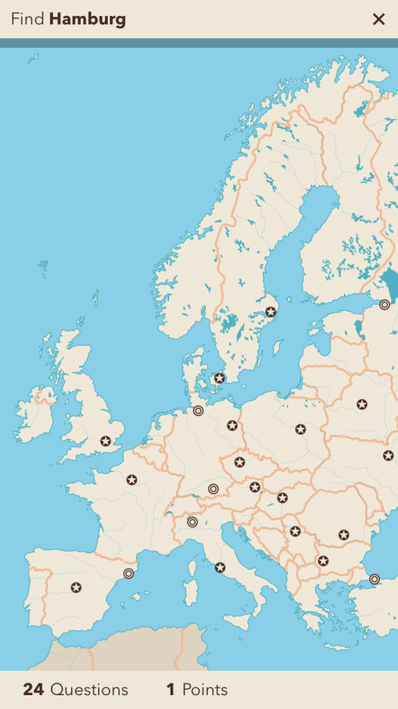
The simulation by Frank McCown can be found if you scroll down on the page. The simulation generates a multitude of questions that can be explored.

    • When do communities remain diverse?
    • When and why does clustering take place even if people are relatively tolerant and open-minded?
    • Can segregated communities be tolerant?
    • Under what circumstances does segregation happen and why?
    • How can a segregated community become diverse?

The Parable of the Polygons contains a group of simulations and uses scaffolding to explore the concept. Contrary to Mc Cown’s simulation the Parable of the Polygons visualise if people are happy or not. Additionally the user can move ONE person and see what happens. The last simulation is a particular interesting one.


The Parable of the Polygons could be used as inspiration for the teacher. However, in our opinion the degree of scaffolding will limit the curiosity, thinking and reasoning by the students themselves.

As teachers we have to be careful how to introduce the simulation and how to discuss the issues. Minority groups in class can easily feel uncomfortable. It is up to the teacher to choose the context and vocabulary that suits the class. As you may have observed have we tried to use the word diversity instead of segregation.

Additionally, the simulations can be used by policy makers, but also by students in relation with religion, geography/demography. It has been known in chemistry that seperate molecules and molecules in small quantities react differently than in mass. The same can be observed with people. Individual people can be tolerant and open-minded, but the large group will nevertheless become clustered under certain conditions.


 Purchase  Free
 Hardware  PC, iPad
 Requirements  Browser